A tour of Public Lands down the spine of Florida for hikers, photographers, and citizen-scientists.

-------

Stop #1 Devil's Millhopper Geological State Park $6 fee one hour
4732 Millhoppper Road Gainesville, Florida 32653One hour hike at the stable sinkhole, including a hike down inside the sinkhole 125 feet on wooden steps and platforms. In the midst of north Florida's sandy terrain and pine forests, a bowl-shaped cavity 125 feet deep leads down to a miniature rain forest. Small streams trickle down the steep slopes of the limestone sinkhole, disappearing through crevices in the ground. Lush vegetation thrives in the shade of the walls even in dry summers. A significant geological formation, Devil's Millhopper is a National Natural Landmark that has been visited by the curious since the early 1880s.
Direct link click here
-----

Stop #2 San Felasco Preserve State Park $4 fee time 2-8 hours depending on trails chosen.
11101 Millhopper Road, Gainesville, FL 32653- 2 miles west of Devils Milhopper.The hiking trailhead is located four miles northwest of Gainesville on State Road 232.There are many trails here, but the must-see feature is Moonshine Creek. Moonshine Creek is located entirely within the preserve. It is formed from a series of seeps (small springs) just north of Millhopper Road. The creek meanders through a ravine until draining into the aquifer through a swallow at its southern end. The Moonshine Creek Trail begins at the parking lot off Millhopper Road. The trail is approximately one mile long. The beginning of the trail passes through sunny pine forests dominated by turkey oak, slash pine, spruce pine, and wiregrass. The trail makes a dramatic change as you enter the ravine. The canopy here is dominated by slash, loblolly, and spruce pines, oaks, hickories, gums, and magnolia. Spotted throughout are sink holes. This is a good example of a mesic mixed hardwood forest. The second half of the creek hike is Creek Sink Trail which is halfway through the Moonshine Creek Trail. Taking this trail will increase your hike to 2.3 miles. This trail goes around the swamps and bottomland forest where the waters of the creek, at the southernmost part of the trail, are absorbed into the underlying aquifer. Hiking "both" trails will show you where the creek begins (seeps) and where it goes underground (sinks).
Virtual Hike Video of San Felasco Hammock Preserve State Park
Direct link to Parks Website
-----------
SIDE TRIP- Alfred Ring City Park (Free) 2 hours 1801 NW 23rd Blvd Gainesville Fl.
NOTE-Park at the Elks Lodge 2424 NW 23rd Blvd.
This park is only "22 Acres" but over a mile of trails wind through upland mixed forest and slope forest, tracing the course of Hogtown Creek. Many short stretches of boardwalk on a long foot path, a botanical and butterfly garden, and a playground.

Alfred Ring City Park Trail and Boardwalks POV Hike
Alfred Ring Park direct website (City Multi-park page)
-------------------------

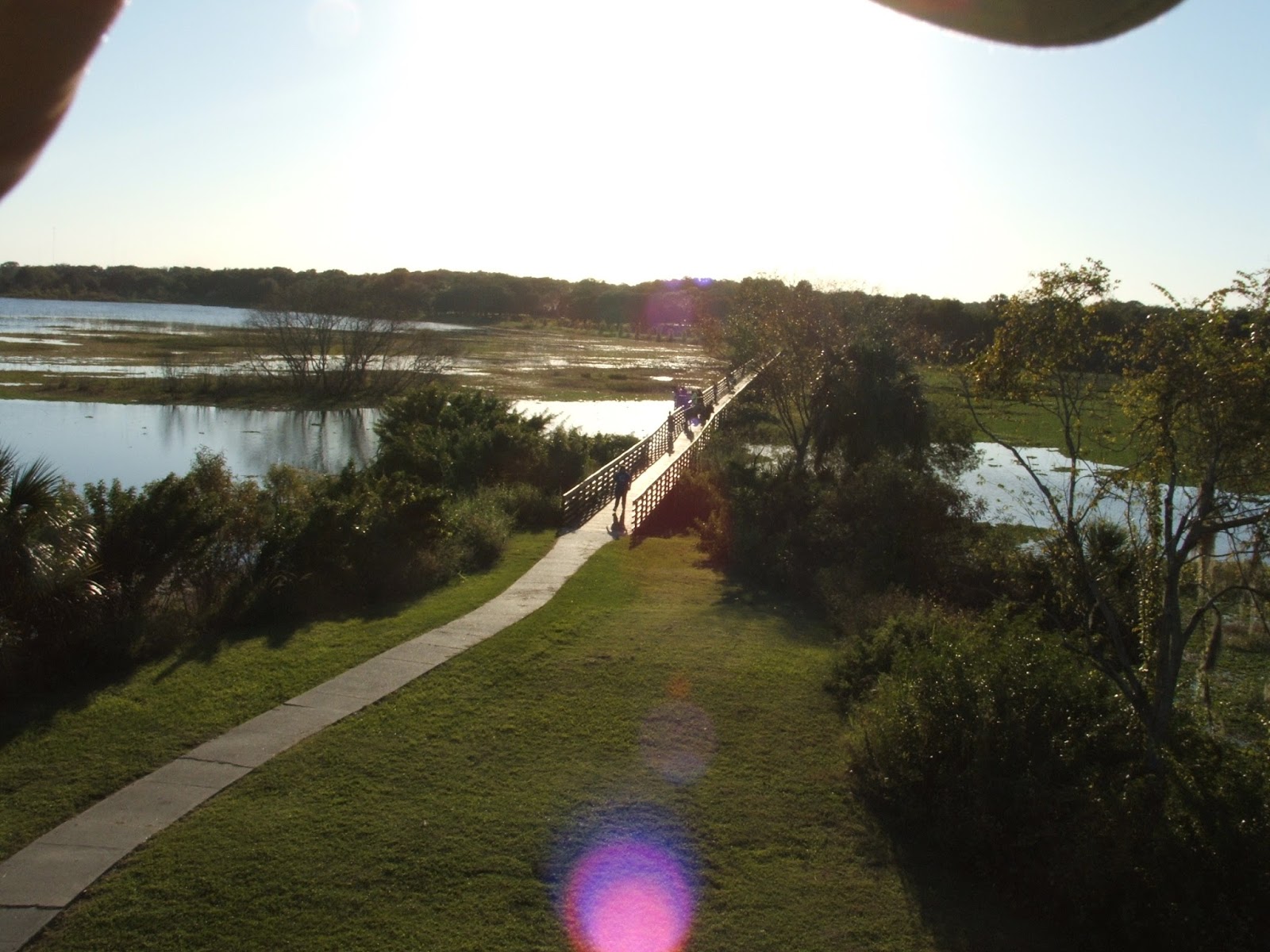
Stop #3 Paynes Prairie Preserve State Park. $6 fee 2-12 hours depending on trails chosen.
100 Savannah Boulevard Micanopy, Florida 32667Eight trails provide opportunities for hiking, horseback riding, and bicycling, including the 16 mile long, paved Gainesville-Hawthorne State Trail. A boardwalk off of US 441 offers a unique view of the wet prairie, another shorter boardwalk along Lake Wauberg offers birding and wildlife observation. The park has two sets of trails. The south 1/2 of the park has a campground, a visitor center, several trails, and a three story observation tower overlooking the prairie to the north. In the visitor center is the death mask of Seminole Indian Chief Osceola. The longer boardwalk and observation platform is located outside the formal park, about 1/2 way between the south and north side on US 441. The northern part of the park has an interpretive center, and one of the trails leads to seeps and springs. Please see the list of trails linked below.
Paynes Prarie Trails link
---------

Stop #4 Ross Prairie State Forest 2-3 hours
Ross Prairie State Forest is located in Marion County approximately ten miles southwest of Ocala. Access is off of SR200, one mile south of County Road 484.Ross Prairie State Forest is located on the southern end of a wetland known as Ross Prairie. This wetland is a freshwater depression marsh characterized by open areas of wetland grasses surrounded by live oak hammocks. These prairies will contain water in the wet season and become completely dry in the dry season. The 150-acre portion of the prairie located on the forest is made up of depression marshes varying in size from one acre to in excess of 50 acres. The Holly Hammock trail is "Trailwalker Program" trail and is a a 2.3-mile, marked hiking trail that meanders through mesic hammocks, sandhills, and along depression marshes. This trail has opportunities for nature study, wildlife viewing, and as photography. According to some researchers, Hernando De Soto found the Native American village of "Ocale" on this site. The remains of the village were destroted during the construction of SR200.
Ross Prairie State Forest direct link
--------------------------------------
You can earn a patch that looks like this
from Florida Dept. of Forestry

Florida State Forestry Dept. How to earn a "Trailwalker" program patch
----------------------------------------

Stop #5 Lake Panasoffkee (closed during hunts) 2-4 hours
7519 NW 18th Way Wildwood, FL 34785 West of exit # 329 of Interstate 75 in Sumner County.There are 18 miles of multi-use and hiking trails. Prepare for wet hiking; some trails are excessively wet during certain times of year. Acquired to preserve Lake Panasoffkee’s vast floodplain forest, the land also preserves pine flatwoods, freshwater marshes and oak scrub forest. As the land continues to rise, pines and scrub oaks of upland sandhills replace the wetland forest trees. This area is home to the Sherman's Fox Squirrel.
Direct link to Preserve webpage.
---------

SIDE TRIP- Seminole Indian War Site- Dade Battlefield Historic State Park $3 fee 1 hour
7200 County Road 603 Bushnell, Florida 33513 East of Interstate 75 exit 314 On December 28, 1835, Indian warriors ambushed 108 U.S. soldiers at this site, and only three soldiers survived. The 80-acre park protects a historic battlefield, and the natural communities as they existed during the war. Wildlife includes gopher tortoises, woodpeckers, songbirds, hawks or indigo snakes. The park's visitor center provides information and displays about the historic battle, as well as a 12 minute video history of the battle This Land, These Men.
Direct link to Dade Battlefield website
-------------------------------------------------

Click here to see a video of some of Florida's Indian Mound Sites open to the public.
----------------------------------

Stop #6 Hillsborough River State Park $6 fee 2-6 hours depending on trails chosen.
15402 U.S. 301 North Thonotosassa, Florida 33592 East of I-75 and North of I-4 Northeast of Tampa.Hillsborough River State Park is one of Florida's first state parks; this original CCC Park is divided by the swiftly flowing Hillsborough River with a set of Class II rapids. Hikers can walk over seven miles of trials: Rapids Trail, Baynard Trail, a sub-section of the Florida Trail, the nature trail, and the Wetlands Restoration Trail.See the virtual Hike Videos below for the River Rapids and Baynard Trails.
The parks interpretive center was built by the Civilian Conservation Corps in the 1930s, and has exhibits and artifacts describing the Seminole Indian Wars. The Interpretive Center is open everyday from 8am to 5pm for visitors to browse through. (See the Fort Foster Side Trip)
Baynard Hiking trail and boardwalks Virtual Hike
River Rapids Trail and boardwalks, Virtual Hike
Direct link to HRSP website
----------

Side trip- Seminole Indian War Site- Fort Foster- Guided Tours on Saturday and Sunday Only
Ranger led tours of Historic Fort Foster Site every Saturday @
2pm & 4pm and on Sunday @ 11am for $2.00 per person. A sub-unit of
Hillsborough River State Park. Fort Foster State Historic Site is part of Hillsborough River State
Park, though located on the East Side of US 301 from the park. Fort
Foster is a reconstructed fort from the Second Seminole War. The Fort is
located 1800 feet from the parking lot and has no restrooms available.
Ranger guided tours of the fort are offered (weather permitting) on
Saturdays at 2:00 pm & 4:00 pm and on Sundays at 11:00 am. Each year
the Fort Foster Historic Site offers a Back in time experience with
two annual events Fort Foster Rendezvous with skirmishes is held in
February and a Candlelight Evening Tour of Fort Foster with a skirmish
is held in December. The Old Fort King Trail is a bicycle path that follows an old indian trail, turned US Army road, that was later paved and designated US Route 301. Fort Foster was built to protect a bridge on this route between Tampa and Ocala. The bike path can be seen flanking US 301 from Hillsborough River State Park south the Sergeant Park. There are several small parks along this strech of US 301 with boardwalk trails. See the Hikers Tour entitled "Tampa's Verdigris Stripe" for more detail.
Tampa's Verdigris Stripe Hikers Tour
---------
Stop #7 Medard Regional Park no fee 1-3 hours
6140 Turkey Creek Road Plant City, FL 33567 Just south of SR 60, east of Brandon.Edward Medard Park is a popular recreation area, hosting 500,000 visitors annually, with the 700-acre reservoir being the main attraction. A boardwalk leads to an observation tower across the reservoir. An out-and-back hiking trail circles from the parking area in a clockwise direction around the reservoir and through the wetlands.
Edward Medard Park website
--------------------------

Stop #9 Circle B Bar Reserve no fee 2-4 hours
4399 Winter Lake Road (SR 540) Lakeland, FL 33803 Just south of the Polk Parkway.Miles of trails , a boardwalks, and an observation platform over Lake Hancock: not to mention the pristine park-like setting around the Polk Discovery Center at the center of the reserve. Circle B is home to some of the most impressive bird activity on SWFWMD property. The tremendous bird population includes a variety of wading birds, waterfowl, ospreys and bald eagles. Alligators inhabit Lake Hancock and may be observed at a distance from shore or from a pier. Oak hammock, freshwater marsh, hardwood swamp and the lakeshore are among the unique characteristics of this property. View the Virtual Hike video below.
Circle B Bar Reserve virtual point-of-view hike.
Direct link to the reserves website
-----------

Side Trip- The Nature Conservancy's Disney Wilderness Preserve.
This preserve is east of the main scope of this tour route, but deserves mention.Nature Conservancy’s Disney Wilderness Preserve 2700 Scrub Jay Trail Kissimmee, FL 34759
The preserve began as the country’s first large-scale, off-site wetlands mitigation project. In the early 1990s, The Walt Disney Co. purchased and donated 8,500 acres to the Conservancy to offset lands impacted by the development of Walt Disney World. Hikers must register at the Adventure Center prior to setting out and allow at least two hours to hike the trail. The hiking trail includes a one-mile trip to Lake Russell. Those wishing a longer experience may continue along the 2.5-mile loop, which offers a closer look at the preserve’s natural communities.
Link to the preserve's website
----------------------
Stop #10 Mosaic's Peace River Park
2200 CR 640 (Homeland-Garfield Road) Bartow, Fl 33830 South of Bartow and east of US 17.This was once a phosphate mine, but now this reclamation project is a public park that borders the Peace River floodplain. The boardwalk is an "E" shape that snakes through the floodplain forest out to the river. See the virtual video hike below.
Peace River Park Boardwalk Point-of-View hike.
Link to Peace River Park website
------------------
LAKE WALES RIDGE
The Lake Wales Ridge National Wildlife Refuge is closed to the public, but these properties have similar wildlife and habitat- Archbold Biological Station, Saddle Blanket Lakes State Preserve, Jack Creek, Catfish Creek, The Nature Conservancy's Tiger Creek Preserve, Lake Wales Ridge State Forest, Lake Wales Ridge WEA, and Lake Arbuckle State Reserve.

Stop #11 Lake Wales Ridge State Forest no fee 3 hours
Access to the Walk in the Water Tract is located 2 miles east of the town of Frostproof on County Road 630. For the other tracts, see the link below. The forest consists of four separate tracts which contain outstanding examples of naturally-functioning ecosystems. The forest offers many recreational opportunities for the rugged outdoor enthusiast as well as the occasional visitor. Hiking trails cross a variety of terrains from forest wetlands to ancient, dry scrub communities. This State Forest contains 4 hiking trails that are included in the Florida Forest Service's Trailwalker Hiking Program. Hikers can take advantage of the numerous hiking trails, which include 20 miles of the Florida Trail.Lake Wales Ridge State Forest direct link
---------------------------------

Stop # 12 Highlands Hammock State Park $6 fee 4 hours
5931 Hammock Road Sebring, Florida 33872Nine hiking trails, three with boardwalks- one of the the famous "Cat Walk Boardwalk". A Civilian Conservation Corps Museum, a restaurant and a scheduled narrated tram tour are available. One of Florida´s oldest parks, opening to the public in 1931, this park was established when local citizens came together to promote the hammock as a candidate for national park status. During the Great Depression, just prior to World War II, the Civilian Conservation Corps (CCC) developed additional park facilities and the beginnings of a botanical garden. This park has historical ties to Archbold Biological Station.
Virtual hike video of the Catwalk Boardwalk at Highlands Hammock SP.
Highlands Hammock direct link
------------

Stop #13 Jack Creek Preserve no fee 4 hours
4501 Grand Concourse Road Sebring, FL 33875Seven miles of unblazed trails are open to hikers. No potable water nor toilets. The unique habitat found on this property includes bay swamp, cutthroat grass seeps, sand pine scrub, hardwood hammock and pine flatwoods. These habitats are rich in natural beauty. The bay swamp habitat dominates the property with abundant red bay, sweet bay and red maple trees. The Jack Creek tract is significant because it protects a large stand of Lake Wales Ridge scrub. This rare community provides habitat for one of the densest concentrations of endangered communities in the world.
Jack Creek Preserve

Stop #14 Lake Wales Ridge Wildlife and Environmental Area
Each sub-unit has its own address so please refer to the direct website.Hiking trails are located on the Royce Unit, Lake Placid Scrub tract and the Carter Creek tract. On other sites, hiking is allowed but there are no trails.During the late 1980s, a group of 40 scientists gathered to design a system of sanctuaries that would protect what remained of the Lake Wales Ridge. Since then local, state, federal and private organizations including The Nature Conservancy have spent more than $75 million in purchasing the best remaining scrub land. The Lake Wales Ridge Ecosystem Working Group, a consortium of nonprofit organizations, federal and state organizations, and local governments, was founded in 1991 to insure the long-term protection of the native plants, animals, and natural communities of this unique region of Florida.
Lake Wales Ridge WEA
--------------------------

Stop #15 Archbold Biological Station no fee 2 hours
(A Private preserve and research facility that is open to the public)
123 Main Dr Venus, FL 33960 Just east of US 17, south of Sebring.Archbold Biological Station, founded in 1941, is a non-profit organization established by Richard Archbold. Archbold Biological Station protects a 5,193-acre globally significant Florida scrub preserve located on the southern end of the Lake Wales Ridge, an ancient sandy ecosystem of south-central Florida. All visitors should register at the new visitor center and complete a liability waiver. Weekend visitors should register at the Information kiosk at the north end of the Plaza. Pictoral exhibits about the Station and its history are in the visitor center M-F 8-5. "Islands in Time,"an 19-minute video narrated by Ken Curtis about the biodiversity and conservation of the Lake Wales Ridge, is available to view free of charge in the Lounge adjacent to the Main Office, M-F 8-5. A half-mile Nature Trail, emphasizes plant identification and scrub ecology. The trail begins at south end of the Main Grounds. Trail booklets are available at the Plaza Kiosk and the Main Office.The original owners of this site, the Roeblings, donated a large sum of money to help Highlands Hammock State Park get purchased and ready for visitors. They then gave this site to world adventurer Richard Archbold so he could study the eco-systems of the Lake Wales Ridge. Archbold, a noted world explorer and scientist, was also part of the team that surveyed Corkscrew Swamp Sanctuary east of Naples.
Link to Archbold Biological Station
-------------------------------------------

Stop #16 Okaloacoochee Slough State Forest $2 Day Use Fee 4 hours
6265 County Road 832 Felda, FL 33930 thirty miles east of Fort Myers, in southeastern Hendry and northeastern Collier counties. There is a boardwalk out into the wet area of the Slough off of Sic Island Loop Rd. South of CR 832.Historicly, the area of Okaloacoochee Slough was heavily logged in the early 1900s as timber was ideal for making railroad cross-ties for a growing railroad system that was developing in southern Florida. During this time, sawmills began to spring up producing small towns dependent on these sawmills. One of these early towns, Sears, stood on the northern border of the forest. After a fire destroyed the sawmill, the town of Sears went into decline and eventually disappeared. During that same time period , the Atlantic Land Improvement Company, Inc. continued harvesting operations by utilizing two portable sawmills, which were referred to as the Twin Mills. Although the sawmills no longer exist on the forest, remnants of sawdust piles can be found on the forest near Twin Mills Grade, which is a "Trailwalker" trail. The Okaloacoochee Slough is one of the few places in south Florida in which the pre-Columbian landscape, north of the Everglades or Big Cypress National Preserve, can be observed. This unique natural system provides a large roaming area of contiguous habitat for a variety of wildlife species. The forest is home to listed, threatened, and endangered species such as the Florida panther, Florida black bear, sandhill crane, wood stork, and gopher tortoise.
Direct Link to this State Forest's website.
-----------------------------------------------

Stop #17 Florida Panther National Wildlife Refuge No Fee 2 hours
Florida Panther Refuge is located 20 miles east of Naples, Florida at the northwest corner of the intersection of I-75 "Alligator Alley" (Exit 80) and State Road 29.Florida Panther National Wildlife Refuge consists of 26,400 acres and is located within the heart of the Big Cypress Basin in southwest Florida. The refuge encompasses the northern origin of the Fakahatchee Strand, the largest cypress strand in the Big Cypress swamp. The refuge is due west of the Big Cypress National Preserve and due north of Fakahatchee Strand State Preserve and Picayune Strand State Forest. Florida Panther National Wildlife Refuge is located in the northern portion of the Fakahatchee Strand of the Big Cypress Swamp. Each month, about a dozen Florida panthers den, hunt, and roam within the refuge. Black bear, bobcat, white-tailed deer, Big Cypress fox squirrels and wood stork utilize the refuge. Large concentrations of wading and water birds feed, nest, and roost on the refuge. The refuge is composed of a variety of wetland and upland habitats including pine flatwoods, cypress strands and domes, wet prairies, tropical hardwood hammocks and hydric pinelands. Rare orchids and bromeliads are found throughout the refuge. Two hiking trails are open to the public on the refuge. The trails are located about a quarter mile north of the intersection of State Road 29 and I-75. Open during daylight hours only, the trails provide the refuge visitor with a chance to experience the various habitats found on the refuge. The Duncan Memorial Trail is a 1/3 mile wheelchair-accessible loop trail that winds through a hardwood hammock dominated by ancient oak trees and tropical vegetation. A small boardwalk and overlook allow visitors to view a small, recently restored, seasonal pond. The longer 1 1/3 mile loop trail is not improved and often floods during the summer, fall and early winter. Additionally, wet conditions prevent the refuge staff from mowing this trail from June through December. The trial is well marked, but during wet conditions, overgrown vegetation on the trail may challenge the hiker. The remainder of the refuge is closed to the public.
Florida Panther NWR website
----------------------------------------

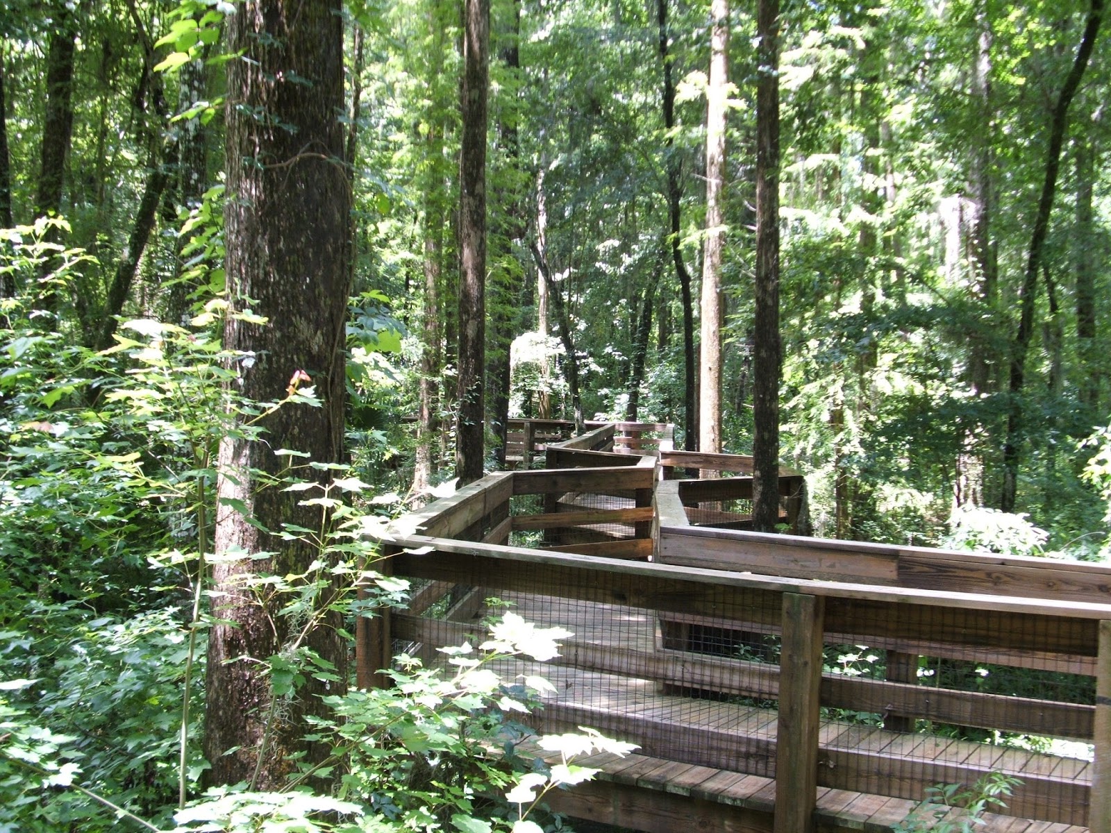
Stop # 18 Fakahatchee Strand Preserve State Park no fee 2-4 hours
Location US-41 about 7 miles west of SR-29, 137 Coast Line Dr. Copeland, FL 34137 The Fakahatchee Strand is a linear swamp forest, approximately twenty miles long by five miles wide and oriented from north to south. It has been sculpted by the movement of water for thousands of years and clean fresh water is the key to its existence. Beneath a protective canopy of bald cypress trees flows a slow moving, shallow river or slough that is warmer than the ambient temperature in the winter and cooler in the summer. The buffering effect of the slough and the deeper lakes that punctuate it shield the forest interior from extreme cold temperatures and this fosters a high level of rare and endangered tropical plant species.The Park hosts a wide array of habitats and forest types from the wetter swamps and prairies to the drier islands of tropical hardwood hammocks and pine rock lands. Its groves of native royal palms are the most abundant in the state and the ecosystem of the Fakahatchee Strand is the only place in the world where bald cypress trees and royal palms share the forest canopy. It is the orchid and bromeliad capital of the continent with 44 native orchids and 14 native bromeliad species. Florida panthers still pursue white-tailed deer from the uplands across the wetlands. Florida black bears and Eastern indigo snakes, Everglades minks and diamondback terrapins can still be found here. An eleven-mile drive down Jane's Scenic Drive truly showcases the park's different natural communities. Accesable from US 41 Tamami Trail a 2,000-foot long boardwalk at Big Cypress Bend, (PICTURED ABOVE) meandering through the old growth cypress, enables the visitor to experience the beauty of this unusual swamp.
Direct link to the Preserves website.
--------------------------------------------------

STOP #19 Ten Thousand Islands National Wildlife Refuge no fee 2 hours
Marsh Trail has a new parking lot and paved trail on the south side of US 41 Tamiami Trail about 14 miles west of SR 29. The ADA compliant paved trail leads to an observation Tower overlooking the refuge. Ten Thousand Islands NWR is located in Collier County on the southwest coast of Florida. Established in 1996, this 35,000 acres refuge protects important mangrove habitats and a rich diversity of native wildlife, including several endangered species. The refuge is part of the largest expanses of mangrove forest in North America. Approximately two thirds of the refuge is mangrove forest, which dominates most tidal fringes and the numerous islands (or keys). The northern third of the refuge consists of brackish marsh and interspersed ponds, and small coastal hammocks of oak, cabbage palms, and tropical hardwoods such as gumbo limbo.Ten Thousand Islands NWR website
-------------------------------------------------------

STOP # 20 Big Cypress National Preserve. no fee up to 8 hours.
The entrance to Big Cypress is located on Interstate 75
(Alligator Alley) and US Highway 41 (Tamiami Trail). These are the main roads
that traverse the site. Visitor facilities and most activities originate from
the Tamiami Trail. Big Cypress National Preserve is
located in some of the most rugged terrain in the state. The preserve
encompasses approximately 729,000 acres of a freshwater swamp ecosystem,
offering refuge to a wide variety of plants and animals.
Plants and animals in the Preserve are protected from unauthorized collection.
Big Cypress National Preserve was created in 1974, to protect the water
quality, natural resources, and ecological integrity of the Big Cypress
Swamp.Big Cypress borders the wet freshwater prairies of Everglades National Park
to the south, and other state and federally protected cypress country in the
west, with water from the Big Cypress flowing south and west into the coastal
Ten Thousand Islands region. In the 1960s, Native Americans, hunters, and
conservationists succeeded at fighting an effort to move Miami International
Airport's international flights to a new airport in the Big Cypress area. They
followed up with a campaign to have Big Cypress included in the National Parks
System. Although construction of the new airport had already begun, it was
stopped after one runway was completed. The best place to begin your visit is at the Big
Cypress Visitor Center at Oasis, which is located on Tamiami Trail (U.S.41)
approximately halfway between Naples and Miami. The visitor center offers a
15-minute movie about the preserve as well as a wildlife exhibit. There is also
a short wildlife viewing boardwalk trail and access to the Florida National
Scenic Trail. Two scenic drives through the preserve provide leisurely wildlife
viewing. The Loop Road is a 26-mile, single-lane, unimproved road beginning and
ending on highway 41. Turner River Road and Birdon Road are a 17-mile
graded-dirt self directed drive. There are over a hundred miles of hiking trails
within the preserve. The Tree Snail Hammock Nature Trail is a short self-guided
trail located on Loop Road.
------------------------------------------------------

STOP # 21 Shark Valley Slough of Everglades National Park $10 fee
Shark Valley Visitor Center 36000 SW 8th Street. Miami, FL 33194From the Naples area, take U.S. 41 (Tamiami Trail) approximately 70 miles east to Shark Valley.
Shark Valley Visitor Center offers educational displays, a park video, an underwater camera and informational brochures. Books, postcards, and other suvenirs are available in the gift store. Guided tram tours, bicycle rentals, snacks and soft drinks are available from Shark Valley Tram Tours, Inc.
\Two short walking trails (one ADA accessible), are located off the main trail for your enjoyment. There is a concrete observation tower (Identical to the one on Clingman's Dome in Great Smoky Mountains National Park), seven miles down the paved road used by Trams and bicyclists.
Shark Valley Entrance- Everglades National Park website
----------------------------------------
Hiking and Boardwalk Facebook Page
Hikers Exchange Point Facebook Group Page
Billy Boardwalk Virtual Hiking Videos


